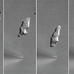
Slime Mold Reveals Clues to Immune Cells’ Directional Abilities
Health & BehaviorHow white blood cells in our immune systems home in on and engulf bacterial invaders—like humans following the scent of oven-fresh pizza—has long been a mystery to scientists. But biologists from UC San Diego and the University of Groningen in the Netherlands have uncovered important clues about this mechanism from a slime mold.