Behind Every Breakthrough
UC San Diego’s WIFIRE Program Provides Real-Time Information to Wildfire Responders
The program helped responders fight the January 2025 fires in Los Angeles and aims to prevent future megafires.

Story by:
Media contact:


Published Date
Story by:
Media contact:
Share This:
Article Content
This story appears in the spring 2025 issue of UC San Diego Magazine as “In Times of Crisis.”
There is no alarm bell ringing or fire pole to slide down at the San Diego Supercomputer Center (SDSC) at UC San Diego’s School of Computing, Information and Data Sciences. Still, at the first sign of wildfire anywhere in California, members of the WIFIRE team are ready.
A unit within SDSC’s Societal Computing and Innovation Lab (SCIL), WIFIRE informs responders with real-time models of how a wildfire will spread, creating predictive maps out of data points such as wind conditions, topography, temperature and the dryness, density and types of foliage that serve as fuel. And on Jan. 7, 2025, when fire was first spotted in the Pacific Palisades neighborhood in west Los Angeles, the WIFIRE team was ready.
“We were staffed up because of the high winds expected,” says Jessica Block, WIFIRE’s associate director of emergency response programs. “And we needed that staff, too. Those were very extreme conditions.” The National Weather Service had previously issued a Particularly Dangerous Situation alert for Southern California, warning of damaging wind gusts, relative humidity below 10% and dry fuels — prime conditions for wildfire.
In the Palisades, a 911 call at 10:30 a.m. for a possible vegetation fire sent an automatic alert to the WIFIRE team, who immediately worked to identify the ignition point. Using UC San Diego’s vast camera and sensor network, ALERTCalifornia, the WIFIRE team triangulated the fire’s position and ran the first of many predictive models they would make over the coming days.
WIFIRE’s predictive software, Firemap, is a custom-built program that integrates a host of data sources, from weather forecasts and ground sensors to satellite imagery and historical fire data. In the past, this sort of modeling was only run after basecamps had been established for immense wildland fires, but the data and computing infrastructure WIFIRE has developed with fire agency partners can now deliver maps within minutes of ignition. Such real-time insights proved to be transformational when WIFIRE developed this system over a decade ago.
“Initial attack is the first moments of responding to a fire, and accurate information is crucial,” says Ilkay Altintas, SDSC chief data science officer and founding director of WIFIRE. “Providing data on where the fire is and where it will be is our priority. When responders have the right information to deploy resources they are better equipped to prevent catastrophic wildfires.”
The first predictive model of the Palisades Fire was delivered to LA responders within minutes of the first sign of smoke. WIFIRE posts these maps to several official channels for fire management officers as a part of FIRIS, or Fire Integrated Real-Time Intelligence System, a response resource hosted by the California Governor’s Office of Emergency Services (Cal OES).
FIRIS was built to enhance the speed and safety of firefighting operations through real-time data integration and also includes two planes equipped with technology to capture important data from above. By using many modes of aerial sensing, including infrared imaging and artificial intelligence, the plane’s equipment can see through immense clouds of smoke and make precise measurements of the fire perimeter.
Though high winds periodically made conditions too dangerous to fly, FIRIS planes collected data whenever possible on the Palisades Fire and subsequent Eaton Fire, which started near the city of Altadena around 6:40 that evening. These perimeter measurements informed WIFIRE’s subsequent models, illustrating the fires’ wind-driven expansion and predicting their paths down canyons and hillsides — valuable information for mass evacuation efforts.
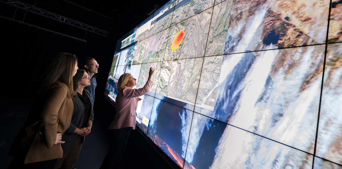
WIFIRE team members, led by Ilkay Altintas (far right), integrate many data sources to model wildfire behavior, providing real-time predictive maps to first responders. (Photo by Erik Jepsen, UC San Diego)
Beyond informing initial attack and evacuation strategies, WIFIRE also performed real-time damage assessment — an essential step in establishing emergency declarations and deploying response aid. New WIFIRE technology used thermal imaging to determine structure fires, a number that swiftly escalated from tens to hundreds to thousands.
The Palisades and Eaton Fires were among the most destructive in LA history, but they weren’t the only ones. Several other fires ignited that night and over the following days in Southern California, any of which could have turned disastrous. “Over those three days of the wind event, we addressed approximately 230 fire starts and published models for 12 verified fires that had the potential for becoming large,” says Block. “But with the right information and firefighting capabilities in place, crews could hit them fast and hard. The FIRIS Fusion Center was instrumental in pivoting FIRIS aerial assets over emerging incidents.”
A History of Collaborative Innovation
This comprehensive system of rapid information sharing has evolved over the years, the product of innovative ideas fueled by unique partnerships. Both WIFIRE and ALERTCalifornia have origins in UC San Diego’s High Performance Wireless Research and Education Network, an infrastructure for wide-area communications via mountaintop nodes. The network’s applications in public safety were recognized early on. After the 2003 Cedar Fire and 2007 Witch Fire in San Diego, Altintas began exploring how to provide responders with real-time, data-driven insights.
“WIFIRE started from federal funding and has become a critical part of public safety. It is a perfect example of how funding research directly benefits the public good.”
Altintas had experience making predictive models for the spread of ocean oil spills with Scripps Institution of Oceanography, and her team at the SDSC adopted a similar approach to data integration for wildfires. Early WIFIRE was built with support from the U.S. National Science Foundation, and partnerships with fire practitioners soon became the basis for a unique cycle of innovation and real-world application.
“We take a use-inspired approach to making data and fire science actionable for decision support,” Altintas says. “We start with a specific societal problem and identify the technology needed to build a solution. Then, we work closely with partners to make science-integrated tools that are sustainable and scalable, and in the process, we uncover new opportunities for application. It’s a continuous loop of working with partners, learning what is needed and solving that need with data, cutting-edge science and technology.”
This use-inspired research cycle permeates the work of the Societal Computing and Innovation Lab (SCIL). The process is even taught to students in SCIL's Convergence Research Institute. But it makes the most immediate impact when put into practice in the hands of responders.

Ilkay Altintas, SDSC chief data science officer and founding director of WIFIRE. (Photo by Erik Jepsen, UC San Diego)
The Los Angeles Fire Department was the first to work with WIFIRE in 2016 and helped refine its models and workflows to be as useful as possible for responders. Early on in their partnership, the department’s Chief Ralph Terrazas called WIFIRE’s Firemap software “one of the most progressive decision-making tools developed in the last decade.”
Over the years, WIFIRE partnerships continued to expand to districts such as the Orange County Fire Authority, which was then spearheading FIRIS, and to governmental bodies such as Cal OES. WIFIRE also supports a similar fire resource network in Colorado. Over the past decade, collaboration within the fire management ecosystem has increased significantly, with WIFIRE playing a key role.
“Our goal is to be the hub that connects institutional research to practitioners using the tools in the real world,” says Melissa Floca, SCIL’s chief innovation officer. “We bridge the gap between R&D and the frontlines, working seamlessly in both worlds to ensure that needs are met and the tools we make are useful and actually used.”
For instance, WIFIRE has a longstanding partnership with the utility company San Diego Gas & Electric, supplying them with data and AI research services as well as WXMap, a real-time fire weather dashboard to inform decisions on weather-related fire risk. And during the recent LA fires, WIFIRE deployed research from a NASA-supported initiative to expand modeling beyond the typical three-hour response window and into extended attack periods of three to five days. For extreme, multiday fire events, insights at this scale could vastly improve preparedness and coordinated response strategies.
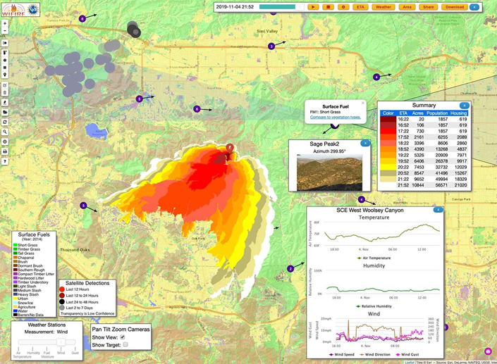
An example of a WIFIRE predictive map. (Image courtesy of WIFIRE, UC San Diego)
“Extended attack is more complicated than initial response, as more variables can happen in that timeframe,” says Altintas. “These grants support the collaboration and development needed to make data and models interpretable and actionable for decision-makers — the right information, at the right time, for the right purpose.”
The lab has also partnered with the Department of Homeland Security to advance the capabilities of edge computing, which is data processing that happens in the field, on the “edge” of standard network connectivity. This capability could be a game-changer for fighting fire in remote areas as well as proactively managing landscapes and mitigating fuel buildup — the next phase in solving our current era of megafires.
Proactive Partnerships Going Forward
“We can’t respond our way out of this wildfire crisis,” says Chris Anthony, the former chief deputy director of CAL FIRE. Anthony was an advocate for the work being done at UC San Diego during his time in the fire service; in his retirement, he became a fellow of the ProWESS Center, a collaboration between UC San Diego and the Los Alamos National Lab focused on proactive measures to prevent and reduce wildfire risk.
“I saw the impact UC San Diego had on the fire service community — not only in aiding response but in applying data to improve fire resilience across the state,” he says. “New technology is necessary to significantly scale prescribed fire programs and make wildlands more resilient.”
In terrain that has not seen a significant fire for decades, built-up fuels increase the risk of catastrophic fire spread. But this can be mitigated by reintroducing fire through controlled, prescribed burns — controlled being the key word. And for greater control, one needs better information.
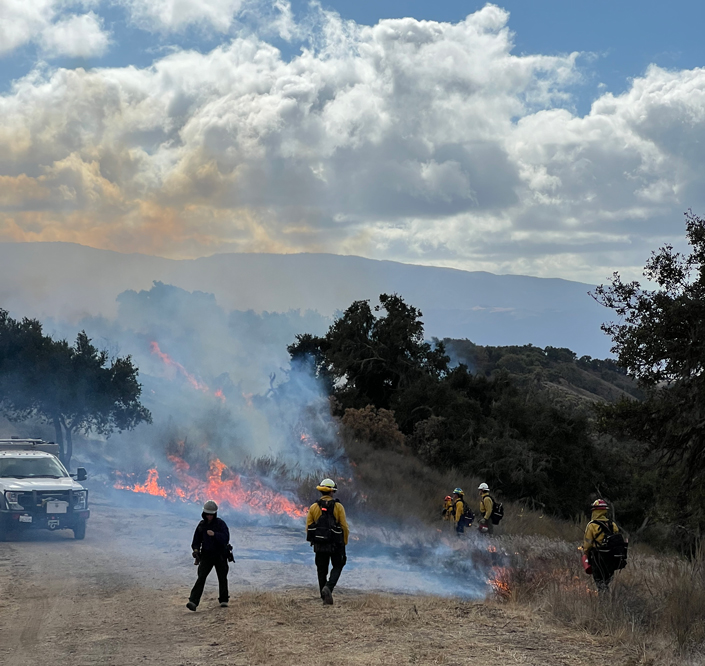
WIFIRE tools like BurnPro3D and Immersive Forest produce digital models of actual wildland terrain to inform prescribed burns. (Photo courtesy of WIFIRE, UC San Diego).
Drawing from their expertise in understanding and modeling fire behavior with WIFIRE, the SCIL team built the modeling program BurnPro3D to help prescribed burn crews plan and predict what a controlled fire will do under different weather and fuel conditions. This is a powerful tool for ensuring these risk-reducing burns are conducted efficiently and safely, and detailed three-dimensional models bring prediction analysis to another level.
“BurnPro3D is designed to support the preparation of burn plans as well as the implementation of burns,” says Anthony. “The interface allows burn bosses to create and visualize high-resolution 3D fire simulations and compare fuel consumption and risk under different weather and ignition scenarios.”
The lab is also advancing modeling with the Immersive Forest Project, which produces digital models of actual forests to virtually simulate the complexity of fire to train researchers, educate policymakers and attract more AI technologists into firetech — all without the need for live burns. And even beyond the fire, the lab is now incorporating smoke management into predictive models, a critical factor for public health and safety.
“We’re doing all these things, but we’re not doing them alone,” says Floca. “Our partnerships and collaborations have helped grow a bigger community of researchers, fire practitioners and public and private organizations that all want to contribute to solutions.”
The SCIL team is actively supporting this community by launching the Wildfire Science and Technology Commons, a new platform to accelerate innovation, foster open science and scale wildfire technology. With a marketplace of data and models, and collaborative workspaces to develop solutions with the fire community, the goal is to drive scalable innovations that advance firetech and effectively address wildfire management.
“Collaboration and support is key to solving our megafire problem and beyond,” says Altintas. “WIFIRE started from federal funding and has become a critical part of public safety. It is a perfect example of how funding research directly benefits the public good. This kind of investment must continue so that solutions can advance and scale to meet our growing societal challenges.”
Learn more about research and education at UC San Diego in: Climate Change, Artificial Intelligence
Share This:


Stay in the Know
Keep up with all the latest from UC San Diego. Subscribe to the newsletter today.