Taking Flight: UC San Diego Shaping Future of Atmospheric River Forecasting
The Atmospheric River Reconnaissance program flies into storms to improve forecasts with the help of AI
Published Date
Story by:
Media contact:
Share This:
Article Content
This year’s rainy season is underway, which means atmospheric rivers are set to dump rain and snow across California and the Pacific Northwest. It also means that specially outfitted aircraft are standing by to fly out to sea into the heart of those brewing storms to improve forecasts as part of the Atmospheric River Reconnaissance program (AR Recon), led by the Center for Western Weather and Water Extremes (CW3E) at UC San Diego’s Scripps Institution of Oceanography and the National Oceanic and Atmospheric Administration (NOAA).
Atmospheric rivers are ribbons of water vapor in the sky that can deliver huge amounts of precipitation. They are simultaneously vital sources of freshwater and the cause of dangerous flooding, making accurate forecasting critically important. Climate change is projected to make these precipitation events more intense and destructive by warming the air, which increases the amount of moisture these storms can carry.
More accurate forecasts and more advanced warnings enhance public safety when flooding is predicted and can support water managers making complex choices ahead of a downpour.

To this end, CW3E works closely with the multi-agency program Forecast Informed Reservoir Operations (FIRO) to provide the latest and best forecasts to help manage water levels in California reservoirs. Accurate forecasts can allow reservoir operators to retain more water, which boosts water availability, or know that it’s time to release water to guard against flooding.
“Climate change is altering the timing, pace and scale of storms,” said Michael Anderson, state climatologist with the California Department of Water Resources. “AR Recon helps us understand the structure of the storms better to improve the precipitation and runoff forecasts enabling water managers to maximize the benefits while minimizing the hazards.”
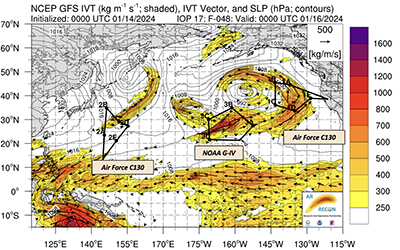
This year’s campaign continues last season’s expansion of flights farther west across the Pacific, this time in Japan instead of Guam, enabling earlier tracking of atmospheric rivers and the potential for greater lead time in forecasts.
This is also the first season in which the CW3E team using AR Recon flight data to create forecasts will have the use of a new supercomputer operated by the San Diego Supercomputer Center at UC San Diego’s new School of Computing, Information and Data Sciences. CW3E’s forecasts are also expanding their use of artificial intelligence (AI), which now includes data-driven models and deep learning algorithms.
Since 2016, the AR Recon program has used “Hurricane Hunter” aircraft from the U.S. Air Force Reserve 53rd Weather Reconnaissance Squadron and the NOAA Gulfstream IV (G-IV) jet to venture into and above intense weather to collect troves of data. Those data are nearly impossible to get through satellites, whose view is often blocked by clouds, or via traditional weather instruments which are sparse in the middle of the ocean where atmospheric rivers typically form.
Collecting data from inside atmospheric rivers allows AR Recon to map their internal structure, get a more accurate sense of how much water they’re transporting as well as better assess their speed and direction of travel — all key pieces of information for generating accurate forecasts.
"Data collected from the AR Recon flights have continued to make a significant positive impact on precipitation forecasts for the U.S. West Coast from NOAA's flagship Global Forecast System," said Vijay Tallapragada, senior scientist at NOAA's Environmental Modeling Center and co-leader of AR Recon. "The impacts are especially higher for extreme precipitation events where as much as 12% improvement in rainfall forecasts were observed, highlighting the need for continued gap-filling measurement of atmospheric and oceanic variables in the vicinity of atmospheric rivers."
In recognition of AR Recon’s position at the cutting edge of atmospheric river science and as a world leader in converting that science into actionable forecasts and recommendations, the World Meteorological Organization (WMO) chose to add AR Recon to its list of 10 World Weather Research Program (WWRP) endorsed projects. The goal of WWRP is to promote research to improve weather prediction, and its impacts on society.
Flying into the storm
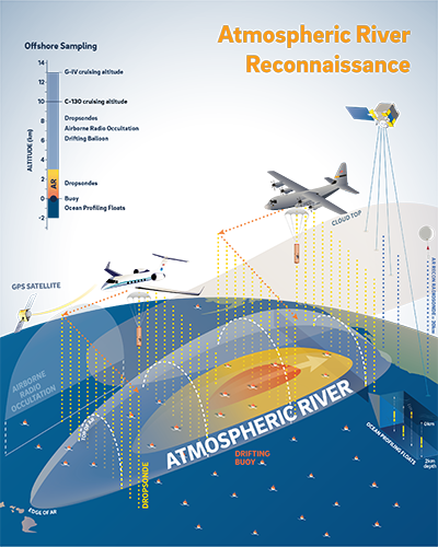
AR Recon collects data using flights, ocean-drifting buoys and weather balloons released from land. The overarching goal is to fill in information gaps by generating direct observations of atmospheric rivers, which improves forecasts and allows for better decision making to mitigate storm impacts.

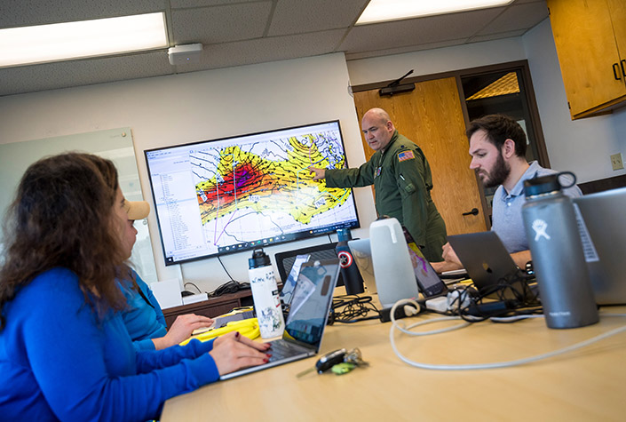
Each flight’s path is meticulously coordinated among scientists, forecasters and navigators to ensure it collects the most useful data about the atmospheric river. The Air Force WC-130J Super Hercules aircraft and NOAA G-IV jet are equipped with an array of sensors to record the state of the atmosphere as they fly. The airplanes also drop cylindrical devices called dropsondes into the atmospheric river that collect information including air temperature, pressure, water vapor, wind direction and wind speed as they descend down via parachute.
Marty Ralph, director of CW3E and co-leader of the AR Recon program, likens the dropsonde data to an MRI scan of an atmospheric river. During the 2023-2024 season, AR Recon conducted 57 flights in the North Pacific and deployed 1,475 dropsondes.
This season, the U.S. Air Force Reserve WC-130J aircraft are available as Air Force resources permit from November 1 through December 18 and then again from March 6, 2025 until March 31. Beginning January 9, 2025, two WC-130J aircraft will be fully assigned and available for AR Recon, based in California until March 5. Another two aircraft will cover the western Pacific from Japan beginning January 28, 2025 through February 15.

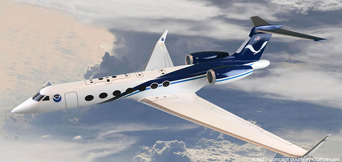
NOAA’s G-IV jet will be stationed in Hawaii and is set to be fully assigned to AR Recon from January 6 through March 13, however the total flight time will not exceed 175 hours which means flights could conclude sooner if it’s an active atmospheric river season. Next year, NOAA is also updating their aircraft from the G-IV to the G550, which is capable of flying longer duration missions. The first of two new G550 aircraft is expected to be operational for the 2025-2026 AR Recon missions.
In addition to these flights, AR Recon adds atmospheric pressure sensors to ocean buoys that collect water temperature and wave measurements as part of the NOAA-funded Global Drifter Program at Scripps. The buoy deployments have been shown to improve forecasts and are a collaboration between CW3E and the Lagrangian Drifter Laboratory at Scripps led by research oceanographer Luca Centurioni.
The 2024-2025 season will see the deployment of roughly 80 drifter buoys via ships and aircraft.
Along with the dropsondes and drifting buoys, AR Recon releases traditional weather balloons called radiosondes from land during the storms to provide additional context. This season, AR Recon will coordinate weather balloon deployments from Tacoma in Washington state and from Bodega Bay and Marysville in California.
From data to forecast
All the data collected by AR Recon is beamed back to land where it is used to generate forecasts in real time. The main way these forecasts are generated is through a model that uses math equations to represent everything science knows about the physics governing Earth’s atmosphere. CW3E’s physics-based model for the U.S. West Coast generates predictions through what’s called a 200-member ensemble.
“An ensemble is a set of simulations – each one slightly different from the next,” said Luca Delle Monache, director of research for CW3E. “It’s like having 200 iterations of the same forecast, which helps you capture the chaos of the atmospheric system where each small change in the starting conditions can alter the forecast.”
For comparison, the main European physics-based atmospheric model uses a 51-member ensemble and the U.S. ensemble has 30 members. Running a high-resolution, 200-member ensemble numerical model requires a massive amount of computing power.
This year’s forecasts are being produced using the new Advanced Warning of Atmospheric River Extremes (AWARE) supercomputer operated by the San Diego Supercomputer Center. AWARE improves on the reliability of its now decommissioned predecessor COMET and adds the capacity for expansion. Over the next six years, the plan is to double and then triple AWARE’s computing capacity to speed up its ability to generate forecasts and to keep pace with the latest AI.

CW3E has been augmenting its physics-based model’s forecasts with various kinds of AI for years, but this year features an expanded role for increasingly powerful AI, which now incorporates data-driven models and deep learning. Each of these AI tools serve to augment the mathematical physics-based model that is the primary engine of CW3E’s forecasts. The new AI approaches can improve the forecast accuracy for some variables by between 10 and 20%, which can translate into one or two extra days of warning, said Delle Monache.
The additional days of warning and added precision in the forecast of atmospheric rivers can make all the difference for reservoir managers participating in the FIRO collaboration. CW3E pilot studies showed that AR Recon-improved forecasts of atmospheric rivers increased water availability at Lake Mendocino in Northern California in collaboration with the Sonoma Water Agency and the U.S. Army Corps of Engineers (USACE), and at the Prado Dam in Southern California.
“The US Army Corps of Engineers has spent the past decade researching how to safely and effectively use forecasts to give water managers more flexibility in their operations through the FIRO program,” said Cary Talbot, national lead for the Forecast Informed Reservoir Operations Program with the US Army Engineer Research and Development Center. “The key in determining FIRO viability at a reservoir is the reliability and accuracy of the precipitation and inflow forecasts. The improved forecasts are giving water managers as much as three additional days of reliable forecast lead time which translates to better decisions about when to release or hold stored water to improve the balance between flood risk management, water availability and ecological benefits provided by USACE reservoirs.”
CW3E and AR Recon are poised to build on this success by adding flights out of the western Pacific, the new AWARE supercomputer, cutting-edge AI as well as new tools on the horizon like the NOAA G550 aircraft and new sensors being tested on this year’s flights. NOAA and CW3E are also developing a new high-resolution, physics-based model called the Atmospheric River Analysis and Forecast System, which, when complete, will further improve forecasts for atmospheric rivers and their impacts for the U.S. West Coast.

"Climate change is making extreme weather events more extreme, and as that happens better forecasts become that much more important," said Ralph. "AR Recon combined with FIRO are potent climate adaptation strategies that help us keep pace with climate change and manage extremes, whether it’s the next drought or the next flood."
Proposed Atmospheric River Legislation
Last month, U.S. Senators Alex Padilla (D-Calif.), and Lisa Murkowski (R-Alaska) introduced bipartisan legislation to reduce flood risks and bolster emergency preparedness by improving atmospheric river forecasting to more precisely predict the timing and location of these storms. The proposed Improving Atmospheric River Forecasts Act would require the National Oceanic and Atmospheric Administration (NOAA) to establish a forecast improvement program within the National Weather Service.
The Improving Atmospheric River Forecasts Act ould direct NOAA to establish a standalone atmospheric river forecast improvement program that would allow the development of accurate and actionable forecasts; evaluate emerging technologies that improve analysis, modeling and forecasts; authorize NOAA to procure equipment and personnel to fully monitor atmospheric river events; improve hazard communication; and more.
“For the past several years, California communities have witnessed firsthand the ongoing threat of destructive flooding caused by intense and frequent atmospheric river storms,” said Senator Padilla. “California scientists have led the way in improving our understanding of these storms, and this bipartisan bill will strengthen forecasts to both reduce flood risks and bolster our water supply and drought resilience.”
AR Recon is supported by the U.S. Army Corps of Engineers and California Department of Water Resources. CW3E partners with California Department of Water Resources, NASA/Jet Propulsion Laboratory, NOAA/National Weather Service, Orange County Water District, San Diego Gas & Electric, Sonoma Water University Corporation for Atmospheric Research, U.S. Army Corps of Engineers, Engineer Research and Development Center, U.S. Bureau of Reclamation, U.S. Geological Survey, Tacoma Water, Water Affiliates Group and the Yuba Water Agency.
Follow the work of Scripps scientists at the Center for Western Weather and Water Extremes on Bluesky at @cw3escripps.bsky.social and X at @CW3E_Scripps, the U.S. Air Force Reserve 53rd Weather Reconnaissance Squadron at @53rdWRS, and NOAA Aircraft Operations Center at @NOAA_HurrHunter.
Share This:
You May Also Like
Stay in the Know
Keep up with all the latest from UC San Diego. Subscribe to the newsletter today.


