Scientists Dig into Sediments for Clues on Carbon Storage
From San Diego to the Galapagos Islands and beyond, Scripps Oceanography researchers are revealing the mysteries of carbon sequestration in aquatic ecosystems


Published Date
Article Content
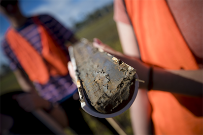
Marine scientist Matthew Costa is used to digging into research—literally. Over the course of his PhD program at UC San Diego’s Scripps Institution of Oceanography, Costa frequently muddied his hands while collecting more than 100 sediment cores from mangrove forests across Latin America.
He and other researchers have turned their attention to these sediment cores to better understand how mangrove ecosystems sequester carbon dioxide, a planet-warming greenhouse gas. This work can then inform local and global efforts that aim to use and restore such ocean and coastal “blue carbon” ecosystems as a possible solution in the fight against climate change.
A special issue of the journal Limnology and Oceanography, published Nov. 30, details new research led by Costa, who graduated from Scripps in 2019. In the paper, he and several co-authors from Scripps Oceanography, UC Riverside, and other research organizations describe their work examining mangrove sediment carbon stocks across regions.
While aquatic ecosystems have the ability to trap tons of carbon for thousands of years, little is known about the factors that control how much carbon is stored in one particular region over another. To uncover this mystery, Costa and colleagues sampled sediments from 80 sites across diverse mangrove environments, including the arid Baja Peninsula of Mexico, the volcanic Galapagos Islands, and the geologically and climatically distinct Caribbean and Pacific coasts of Panama.
One of their key findings was that variation in maximum sediment depth—ranging from seven to 427 centimeters (2.8 to 168 inches) across sites—largely explained variation in carbon stocks in those areas. These results underscore the importance of using measurements of sediment depth to estimate carbon stock.
“There's a lot of local variation in how much carbon is buried beneath those mangroves, and the most important contributor to that variation is just how deep the sediment goes,” said Costa, now a postdoctoral researcher at Northeastern University and a visiting scholar at Scripps Oceanography. “Some studies ignore this variable, but it's essential to understanding both the history of how these sites attained these carbon stocks and where we should place the highest priority in protecting and managing them to keep mitigating climate change.”
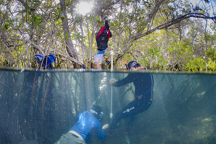
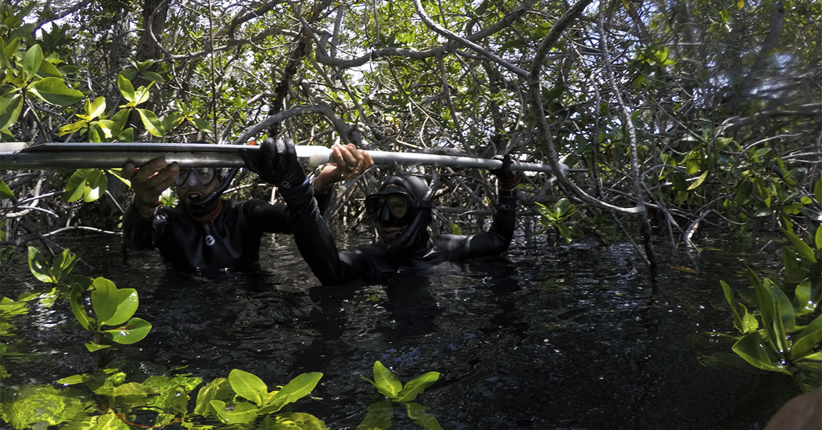
Researchers Ismael Mascarenas, Juan José Cota-Nieto, and Matthew Costa drive a sediment corer into the flooded mangrove forest floor to collect a sample in the Galapagos Islands. Photo credit: Octavio Aburto-Oropeza
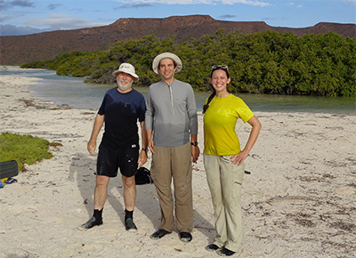
Researchers Exequiel Ezcurra, Matthew Costa, and Emma Aronson on Isla Espíritu Santo in the Gulf of California, off Baja California Sur, Mexico, in 2015. They visited the site to collect deep sediment cores for analysis. Photo: Jon Botthoff
In measuring carbon storage, researchers typically look at carbon density—how much carbon is in the sediment per unit volume—and then scale that up to quantify how much sediment there is in an area. Costa noted that many studies just make those measurements based on the first half meter or so of sediment, and then scale up.
But in analyzing sediment cores in diverse and remote environments in Latin America, the research team exposed the enormous variation in sediment depths across each area. For example, within the different regions, such as the Galapagos, they found a “huge amount” of variation in sediment depth within sites that were only a few miles apart.
Costa said this research is significant as the team has added to the range of environments in which there are now data on carbon storage in mangroves. By increasing these local measurements, the research community can better map out estimates of carbon storage across study sites, and in turn help inform habitat protection efforts.
Study co-author Paula Ezcurra said this research is unique in that it utilizes datasets of belowground carbon in mangrove sediments across vastly different settings.
“The results highlight that although we’re looking at similar ecosystems—i.e. coastal mangrove forests in Latin America—there exists a wide range of climatic and geological conditions under which mangrove forests can thrive,” said Ezcurra, a former researcher at Scripps Oceanography who is now the science program manager at the Climate Science Alliance. “These differences affect each forest's ability to sequester and store organic carbon in their soils—something we know to be beneficial in the mitigation of climate change and reduction of atmospheric carbon.”
Connection to Local Wetlands
While the new paper focuses on mangrove ecosystems, the findings can be applied to research on other coastal ecosystems known for blue carbon storage, such as salt marshes and seagrass beds.
Upon graduating from Scripps Oceanography in 2019, Costa began working as a postdoctoral scholar at the Center for Climate Change Impacts and Adaptation (CCCIA) at Scripps Oceanography, focusing his research on local subtidal blue carbon ecosystems—meaning carbon that was buried in environments completely underwater, such as the seagrass beds and canyons off La Jolla.
He also started examining carbon sequestration in protected and restored wetlands across San Diego County. As part of this work, Costa has been collaborating with researchers at WILDCOAST—a non-profit dedicated to ecosystem conservation—and the San Diego Audubon Society to build baseline blue carbon datasets for San Diego’s wetlands. He has already engaged in extensive fieldwork to collect sediment cores from key sites including San Dieguito Lagoon, Famosa Slough, and Kendall-Frost Mission Bay Marsh Reserve, which is part of the University of California Natural Reserve System.
"We know that coastal wetlands are valuable for both the long-term carbon storage and the many other ecosystem services they provide,” said Mary Liesegang, blue carbon conservation manager at WILDCOAST. “The research collaboration between WILDCOAST and Scripps Oceanography is important because it provides an opportunity to quantify that value in terms of carbon storage. These results allow us to determine the most effective restoration practices and policy to ensure that coastal wetlands remain a carbon sink for years to come."
Similar to observations seen in remote mangrove ecosystems, Costa has found sediment variability in San Diego’s urban estuaries, noting that one side of an estuary might have sediment only 15 centimeters deep while the other side might go three meters deep. The new study shows that these wide variations in depth need to be considered in any calculations of carbon stock.
“The most important variable that controls how much carbon is stored in coastal wetlands, whether it's a mangrove or another ecosystem like a salt marsh, is very simply how much carbon-rich sediment there is,” Costa explained.
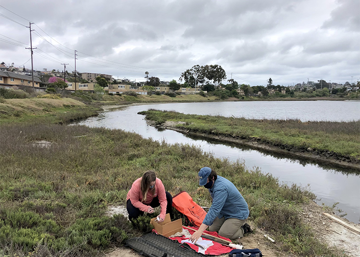
WILDCOAST Conservation Director Angela Kemsley and Scripps Oceanography researcher Matthew Costa examine sediment samples collected at San Diego's Famosa Slough in 2021.
A sediment core collected at Kendall-Frost Mission Bay Marsh Reserve. Photo: Erik Jepsen/UC San Diego
In coastal cities where wetlands are both the most threatened by and the most needed to mitigate climate impacts, Costa said it is especially valuable to get more local measurements to map out the belowground landscape. This will help researchers to better understand how the resource of wetland carbon is distributed around this part of the California coast.
“These findings will be extremely useful to stakeholders for coastal planning, conservation, and restoration, particularly in high-priority areas,” said Costa.
Those data are still being collected and prepared, but the researchers hope to share results soon.
In addition to Costa and Paula Ezcurra, co-authors of the Limnology and Oceanography paper are Exequiel Ezcurra with UC Riverside; Joy Kumagai, James Leichter, and Octavio Aburto-Oropeza with Scripps Oceanography; Pelayo Salinas-de-León with the Charles Darwin Foundation; and Benjamin Turner, who is currently affiliated with the University of Florida Gainesville.
Costa’s PhD field work was supported by the Helmsley Charitable Trust, the NSF Graduate Research Internship Program, and the Smithsonian Tropical Research Institute Short-Term Fellowship. His sampling in the Baja Peninsula and sample analysis was supported by the Mia Tegner Memorial Fellowship and the UC Institute for Mexico and the United States (UC MEXUS) dissertation research grant programs.
Learn more about research and education at UC San Diego in: Climate Change
Share This:


Stay in the Know
Keep up with all the latest from UC San Diego. Subscribe to the newsletter today.