Archaeologists Show Unmanned Robotic Vehicles Offer Solution to Challenges Mapping Underwater Sites


Published Date
Article Content
According to the United Nations Educational, Scientific and Cultural Organization (UNESCO), for more than 90% of the existence of humankind, the sea was 40–130 meters (130–425 feet) lower than it is today. That means, due to current higher water levels, much information about ancient human civilizations now lies underwater. Yet marine archaeology is expensive, and even small research vessels have difficulty deploying scientific instruments safely and effectively in shallow water near shore.
Now, in a paper prepared for this fall’s International Conference on Metrology for Archaeology and Cultural Heritage (IMEKO) in Rome, Italy, a team from University of Patras and UC San Diego have shown that robotic unmanned surface vessels (USVs) offer a potential solution to collecting information from these valuable cultural heritage sites.
“This paper provides a low-cost solution to collecting high-resolution mapping data of very shallow submerged archaeology sites, in this case, shipwrecks,” said Thomas Levy, who is co-director of the UC San Diego Qualcomm Institute’s Center for Cyber-Archaeology and Sustainability (CCAS) as well as a Distinguished Professor of the UC San Diego Graduate Division and inaugural holder of the Norma Kershaw Chair in the Archaeology of Ancient Israel and Neighboring Lands in the Department of Anthropology.
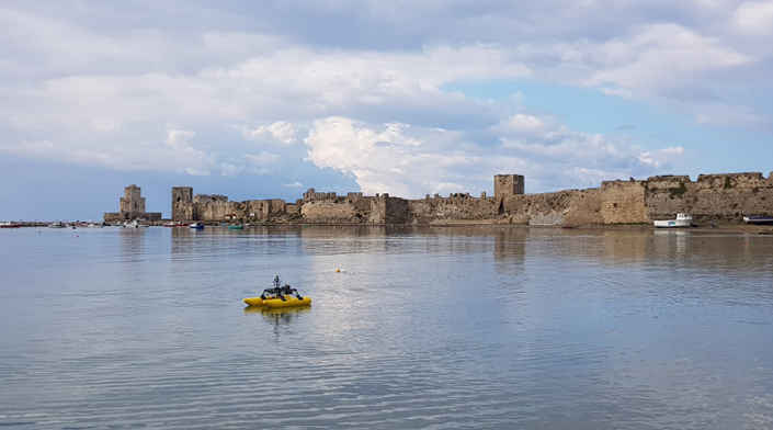
The catamaran-shaped robotic vessel with a side scan sonar system surveys the shallow water in front of the Venetian Fortress on the Methoni Bay, Greece. (Photo courtesy Tom Levy, CCAS, UC San Diego)
Charted and Uncharted Waters
To test the potential of the USV, Professor George Papatheodorou harnessed the joint UC San Diego–University of Patras underwater cultural heritage project in Methoni, Greece. Papatheodorou and his colleague Prof. M. Geraga run the Oceanus Lab, Laboratory of Marine Geology and Physical Oceanography at University of Patras, which Levy cites as one of the world’s best for innovation and field research in shallow marine geophysics for cultural heritage research.
In conjunction with a Greek company called Intelligent Machines and their researcher Nikos Mauromatis, they developed a catamaran-shaped USV equipped with a side scan sonar system. The vehicle was deployed at two underwater wreck sites in Methoni Bay, Greece. The data collected were then processed with ReefMaster and SeaView software to generate mosaics for inspecting and mapping the two sites.

The USV, which was designed by Intelligent Machines, Patras, Greece, is videotaped by UC San Diego diver Tony Tamberino using a Sony a7R camera in a Nauticam underwater camera housing (Photo courtesy Tom Levy, CCAS, UC San Diego).
Once the results were in, team members compared the USV assessments with those collected with a conventional geophysical survey. The results, they concluded, were identical.
Levy is optimistic about the utility of the USV technology for marine archaeologists, especially in shallow water environments under about 3 meters/10 feet, where larger research vessels cannot operate.
Acknowledging that the downsides of USVs include the possibility of battery, electronics and mechanical failures in the field, Levy noted the robotic vehicles also offer many advantages. These include extended autonomous operation, maneuverability, and low power consumption. In addition, since boats operating over shallow submerged archaeological remains can damage sites, USVs can have less environmental impact.
“The USVs are ideal for getting in close to the shore to record and map,” said Levy.
The paper, “A low cost Unmanned Surface Vehicle for mapping shallow-water UCH sites: Ancient and historical shipwrecks in Methoni bay, Greece” was authored by Giannakopoulos Vasileios, Papatheodorou George, Christodoulou Dimitris, Fakiris Elias, Maria Geraga, Panagiotis Gkionis, Nikos Mavrommatis, and Thomas Levy. It will be presented at 2023 IMEKO International Conference on Metrology for Archaeology and Cultural Heritage from October 19 to 21, 2023 and published in the Conference Proceedings.
Share This:
You May Also Like


Stay in the Know
Keep up with all the latest from UC San Diego. Subscribe to the newsletter today.