Archaeologists Investigate Past Impact of Sea-Level Changes at Israeli Coastal Sites
Published Date
By:
- Doug Ramseey
Share This:
Article Content
A multinational team of archaeologists and scientists is reassessing the history of sea-level change in the Eastern Mediterranean based on underwater excavation and photogrammetry at sites on Israel’s Carmel coast.
The new findings, published today in the open-source journal PLOS ONE*, are based on archaeological constructions near Tel Dor dating back to the Middle Bronze Age roughly 3,800 years ago up to the end of the Roman period (1,800 years ago).
“Our observations and analysis of submerged buildings and infrastructure have allowed us to establish a more reliable relative sea level for the Carmel coast and Southern Levant,” said principal investigator Assaf Yasur-Landau, director of the University of Haifa’s Leon Recanati Institute for Maritime Studies. “Understanding sea-level change is critical because this coastline has been inhabited continuously for thousands of years.”
“This is the first study of sea levels in Israel which included new data on the critical historical periods of the Iron Age to the Hellenistic periods for which almost no data existed before,” explained co-author Dorit Sivan, a University of Haifa professor and pioneer of archaeological sea level research in Israel. Other institutions participating in the project included the University of California San Diego, University of Bologna, and Italy’s National Institute of Geophysics and Vulcanology.
The team found that Iron Age harbor structures at Dor remained at roughly the same elevation for 400 years when the relative sea level was roughly 2.5 meters below present levels. That period of stability began to change in the Hellenistic period, with sea level rising rapidly during the Hellenistic through the end of the Roman period approximately 1,800 years ago.
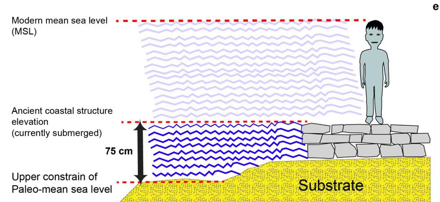
Illustration showing the relationship between the coastal archaeological construction and its use for establishing the relative mean sea level. (Illustration courtesy Gilad Shtienberg, SCMA, UC San Diego)
According to UC San Diego archaeologist Thomas E. Levy, a co-author on the new paper and co-director of the Scripps Center for Marine Archaeology (SCMA) in the Scripps Institution of Oceanography, the main social impact of sea-level rise is relocation and sometimes, forced migration. He points to the team’s December 2020 publication in PLOS ONE, which identified a mega-tsunami in the early Neolithic period. “The Carmel coastal wetland environment disappeared after the tsunami,” said Levy, a professor in the Department of Anthropology in UC San Diego’s Division of Social Sciences. “Neolithic villagers had been beautifully adapted to the coastal environment, but the Neolithic landscape was submerged by sea-level rise and the people were forced to move to higher ground away from the coastal plain.”
“The situation in the later periods covered by this new publication is much more nuanced, as Assaf has shown," added Levy, who also directs the Qualcomm Institute’s Center for Cyber-Archaeology and Sustainability at UC San Diego.
Historical and archaeological sources have revealed the decline and occasional disappearance of Hellenistic sites along the coast of Israel ca. 2nd century BCE, including at Yavneh Yam, Ashdod Yam, Straton’s Tower and Tel Taninim. The latest paper attributes this decline to the long period of rising sea levels. “All along the Israeli coast, Hellenistic harbors and anchorages would have been hampered in their activity, and artificial harbor installations would have ceased to serve their function, even if occasionally modified,” according to the study. “The economic setbacks and occupational gaps witnessed in the local coastal settlements starting in the 2nd century BCE may be connected to this phenomenon.”
The authors also note that at Akko-Ptolemais, “the large harbor installations built in the Hellenistic period were never replaced by a substantial Roman harbor.”
“The entire coastal Southern Levant appears to have put on hold all prospects for an improved maritime interface,” observed Yasur-Landau. “With the relics of earlier installations still protruding dysfunctionally out of the water, knowledge of the rising sea level and its rapid pace would have been widely available, serving as a painful reminder of past glory for such cities as Dor and Akko, and as a clear discouragement of investment in coastal facilities for the entire area.”
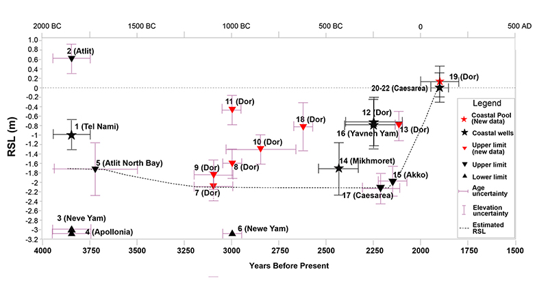
Computed relative sea level for the coast of Israel with the chronological and vertical uncertainties
UC San Diego’s Levy points out, “In addition to underwater excavation, our team used photogrammetry, the science of precisely measuring objects from numerous sets of photographs that are then processed with computer programs to generate 3D images of the different sites. This relatively new technique helped us nail down and measure the rising sea level.”
Dor, the principal site investigated for the latest study, is located 21 km south of Haifa and 13 km north of Caesarea. It was settled in the Middle and Late Bronze Ages and remained inhabited through some 2,300 years until the end of the Roman period. “Dor’s rich settlement history as a coastal port site makes it an ideal case for a diachronic study of archaeological proxies for sea-level changes, providing examples of harbor and coastal installations dating from the Early Iron Age to the Roman period,” explained the University of Haifa’s Yasur-Landau.
Much of the newest data was gathered in 2018 during a joint expedition undertaken by UC San Diego and the University of Haifa with funding from the Koret Foundation.
Citation
* Yasur-Landau A, Shtienberg G, Gambash G, Spada G, Melini D, Arkin-Shalev E, et al. (2021) New relative sea-level (RSL) indications from the Eastern Mediterranean: Middle Bronze Age to the Roman period (~3800–1800 y BP) archaeological constructions at Dor, the Carmel coast, Israel. PLoS ONE 16(6): e0251870. https://doi.org/10.1371/journal.pone.0251870
Share This:


Stay in the Know
Keep up with all the latest from UC San Diego. Subscribe to the newsletter today.