Atmospheric River Reconnaissance Flights Get an Early Start this Winter
Air Force and NOAA aircraft collecting data over the Pacific from November to March
Published Date
Story by:
Media contact:
Topics covered:
Share This:
Article Content
An expanded Atmospheric River Reconnaissance program began last month as a result of the unexpected “bomb cyclone” in October 2021 that hit North America’s West Coast, followed by another atmospheric river less than a month later that caused severe flooding in Washington.
“Climatologically, November and December can bring some of the worst floods for that part of the world,” said research meteorologist Marty Ralph, director of the Center for Western Weather and Water Extremes (CW3E) at UC San Diego’s Scripps Institution of Oceanography. Ralph leads the AR Recon program, along with Vijay Tallapragada, Ph.D., Senior Scientist at NOAA’s Environmental Modeling Center, in partnership with the U.S. Army Corps of Engineers, the California Dept. of Water Resources, NOAA Office of Marine and Aviation Operations, and the U.S. Air Force Reserve 53rd Weather Reconnaissance Squadron “Hurricane Hunters.”
Atmospheric rivers are streams of water vapor that carry 25 times the water equivalent of the Mississippi River. Flowing at an altitude of about 10,000 feet, atmospheric rivers average between 100 and 500 miles wide and 2,000 miles long. Where they hit the West Coast determines where heavy rain, snow, and flooding occurs. They are also critical to water supply, and improved forecasts of where atmospheric rivers will make landfall are vital for more effective management of reservoirs.
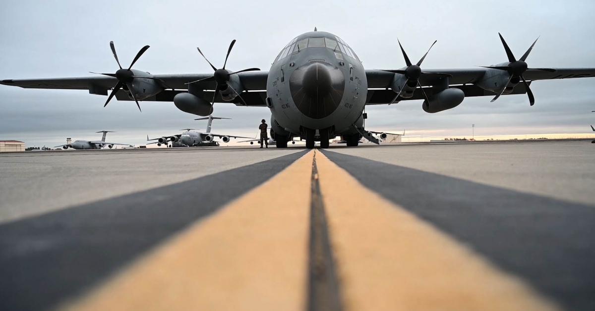
New this year, the U.S. Air Force Reserve will provide two WC-130J Super Hercules aircraft to fly with the Weather Reconnaissance Squadron Hurricane Hunters on “resources permitting status” beginning in November and through December 2022. This means that while the aircraft will not yet be stationed on the West Coast, the squadron is on call to fly missions to collect data on incoming atmospheric rivers as they develop.
According to Anna Wilson, the field research manager for CW3E who oversees AR Recon operations, the U.S. Air Force Reserve has already flown two flights this month, on Nov. 5 to collect data on a strong atmospheric river affecting the Pacific Northwest, and on Nov. 6, to collect data on the atmospheric river as it moved south towards California.
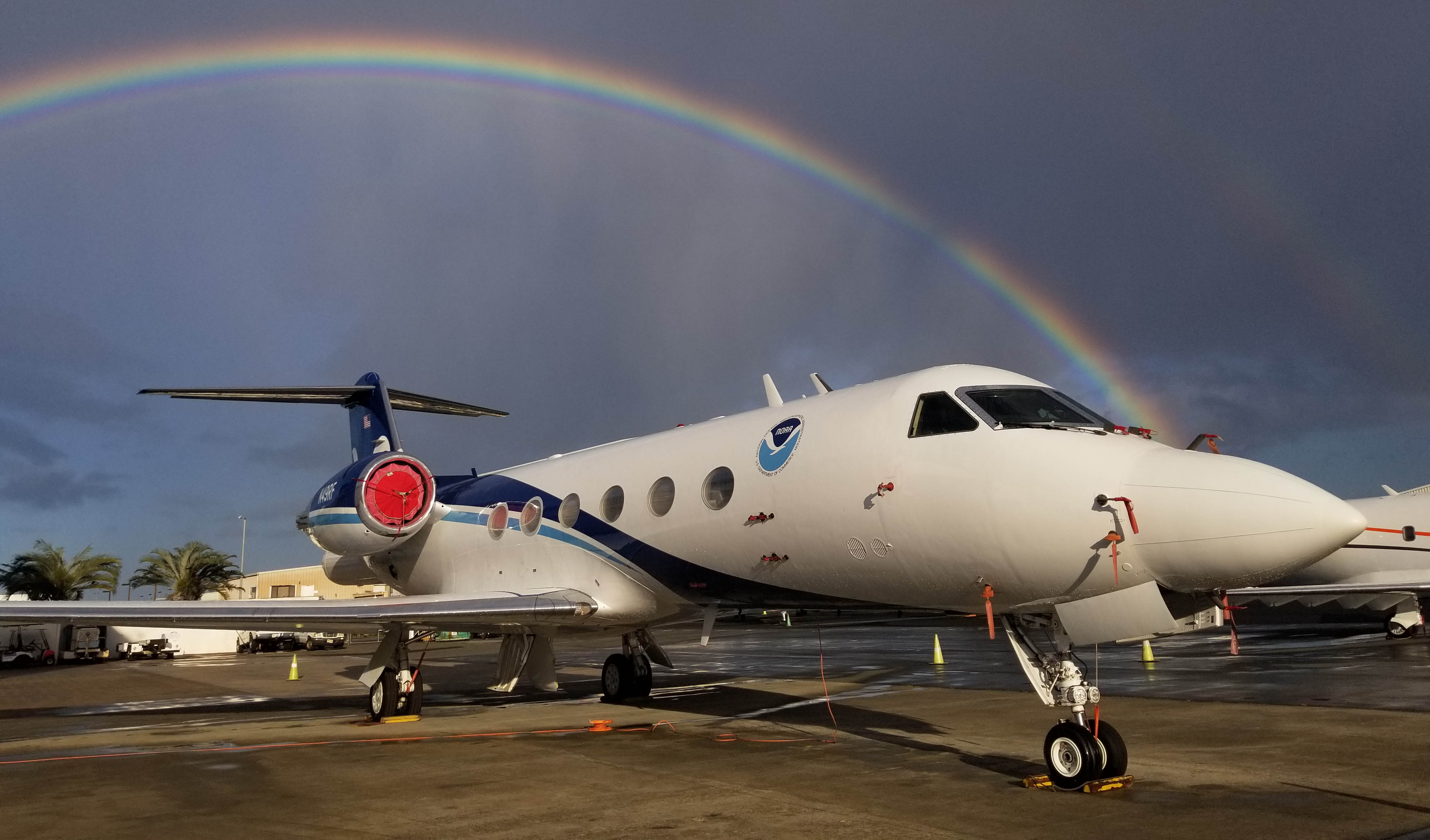
The squadron will be fully assigned to AR Recon in January and February, then, as resources permit, again in March. A NOAA Gulfstream IV jet stationed out of Hawaii is available to fly AR Recon missions in December and January.

These “Hurricane Hunter” aircraft from both the Air Force Reserve and NOAA deploy dropsondes, instruments measuring 16 inches long and less than three inches in diameter that drop by parachute. During their 20-minute journey to the ocean surface, they transmit data back to the aircraft about temperature, pressure, water vapor, and winds. The resulting data is relayed to a central repository that feeds global weather forecasts.
AR Recon data help improve weather forecasts and related longer-term research. The program began with a three-week program in February 2016. It steadily grew to cover from early January to mid-March in 2020 and 2021. The program, which is now part of the federal National Winter Season Operations Plan, has expanded as the data collected from the reconnaissance missions has been demonstrated to improve operational forecasts. NOAA's newly released Aircraft Plan highlights how the NOAA G-IV atmospheric river support needs to double in 2023, expanding support from a partial to a full season to collect the critical data to support accurate forecasts. The NOAA Aircraft Plan highlights the need for a second G550 to provide this data, in addition to the G550 being acquired to replace the NOAA G-IV.
“The data collected from NOAA’s G-IV and the U.S. Air Force’s WC-130’s are assimilated in real-time into NOAA’s Global Forecast System in an effort to improve short-to-medium range precipitation forecasts for the U.S. West Coast up to 7 days out,” said Tallapragada. “Results over a 5-year period of evaluation from 2016 to 2022 demonstrated significant improvement in precipitation forecasts over regions impacted by Atmospheric Rivers when the aircraft reconnaissance data is assimilated in real-time into the Global Forecast System.”
“There's a major drought underway in the southwestern U.S and California is entering at least its third year of drought. And yet, in the Pacific Northwest, the last three winters have each triggered a presidentially declared flood disaster associated with landfalling atmospheric rivers,” Ralph said.
The aircraft also will collect data using an airborne radio occultation technique invented by Jennifer Haase, a Scripps Oceanography geophysicist and atmospheric scientist. The technique uses GPS signals to detect variations in atmospheric properties and provide key moisture and temperature data about the environment surrounding the aircraft flight path and the dropsondes beneath it.
The Air Force also deployed a total of 50 buoys Nov. 17 and Nov. 20 to collect key data on sea-level atmospheric pressure, water temperature and wave measurements. The deployment buoy drops into the data-sparse northwest Pacific Ocean for the first time. Data collected in this area provides scientists important information even further upstream, giving them the ability to improve forecasts further out.
The buoy deployments are a collaboration between CW3E and the Lagrangian Drifter Laboratory (LDL) at Scripps. LDL Director Luca Centurioni also heads the NOAA-funded Global Drifter Program, which observes surface physical processes on the global ocean that improve understanding of hurricanes and other phenomena. Drifters are deployed in areas of the Pacific where atmospheric rivers form and flow toward the West Coast.
“More than 40 of the previously deployed drifters continue to send back data that is available via the Global Telecommunications System for open use by the meteorological, forecasting, and scientific community,” Centurioni said. The drifters record observations of key variables, such as sea-level atmospheric pressure, allowing for better modeling and forecasting.
The collaboration has proven to be a cost-effective way for both programs to collect atmospheric pressure data.
“Sea-level pressure measurement is very useful for weather prediction,” Ralph said. “And those data are assimilated like the dropsonde data into global weather prediction models.”
The AR Recon program also will begin working more closely with Forecast-Informed Reservoir Operations (FIRO), a multi-agency effort to manage water levels in California reservoirs most efficiently. CW3E already has done pilot studies showing increased water reliability at Lake Mendocino in Northern California, with the Sonoma Water Agency and the U.S. Army Corps of Engineers, and at the Prado Dam in Southern California.
“We have proven that with good forecasts of ARs making landfall in that area, it has been possible to operate the reservoirs more flexibly,” Ralph said. “After a big storm, normally they would have to release that extra water quickly, assuming there might be a storm the next day.”
But if no AR is predicted to come within the next few days, the operators can hold the extra water, a vital benefit during droughts.
Both options—holding extra water in dry periods and releasing it during wet periods—are needed to deal with the new extreme conditions that climate change brings.
“The wets are getting wetter, and the dries are getting drier. And the ARs are the key player in both,” Ralph said.
Follow the work of Scripps scientists at the Center for Western Weather and Water Extremes on Twitter at @CW3E_Scripps, the U.S. Air Force Reserve 53rd Weather Reconnaissance Squadron at @53rdWRS, and NOAA Aircraft Operations Center at @NOAA_HurrHunter.
Learn more about research and education at UC San Diego in: Climate Change
Topics covered:
Share This:
You May Also Like
Stay in the Know
Keep up with all the latest from UC San Diego. Subscribe to the newsletter today.


