New Study Identifies Atmospheric Rivers as Contributor to Increased Snow Mass in West Antarctica
New satellite enabled detailed measurement of extreme precipitation events
Published Date
By:
- Lauren Fimbres Wood
Share This:
Article Content
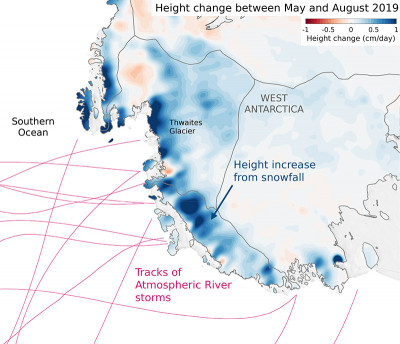
A new study published today in the journal Geophysical Research Letters used NASA’s ice-measuring laser satellite to identify atmospheric river storms as a key driver of increased snowfall in West Antarctica during the 2019 austral winter.
These findings from scientists at Scripps Institution of Oceanography at the University of California San Diego and colleagues will help improve overall understanding of the processes driving change in Antarctica, and lead to better predictions of sea-level rise. The study was funded by NASA, with additional support from the Rhodium Group’s Climate Impact Lab, a consortium of leading research institutions examining the risks of climate change.
Atmospheric rivers are phenomena that transport large amounts of water vapor in long, narrow “rivers” in the sky. They are known to be the main driver of precipitation along the West Coast of the United States, accounting for 25-50 percent of annual precipitation in key parts of the West. Increasing research on atmospheric rivers finds that they dominantly impact the western coasts of most continents, due to oceans evaporating and storms building high levels of moisture into the atmosphere.
NASA’s Ice, Cloud, and land Elevation Satellite-2 (ICESat-2), launched into orbit in September 2018, is providing a detailed look at the height of ice and snow on the vast, frozen continent. The satellite works by sending 10,000 laser pulses per second to Earth’s surface that measure the height of ice sheets, glaciers, and more by calculating the time it takes a handful of those pulses to return to the satellite. Each photon of light has a time tag, and these tags combine with the GPS location to pinpoint its exact place and height on the ground. It measures a detailed set of tracks over the Antarctic ice sheet every three months.
“ICESat-2 is the first satellite to be able to measure snowfall over the Antarctic continent in such a precise way,” said Helen Amanda Fricker, a glaciologist at Scripps Oceanography and co-author of the study. “In winter, weather conditions prohibit having a field team there making observations on the ground. ICESat-2 is filling in this lack of data over the vast ice sheets, and giving us a greater understanding of snow mass gain and loss on a seasonal scale.”
Looking at ICESat-2 data, scientists found increases in height over the Antarctic Ice Sheet between April 2019 and June 2020 due to increased snowfall. Using a computational model of the atmosphere and snow, they found that 41 percent of height increases over West Antarctica during the 2019 winter occurred because intermittent extreme precipitation events delivered large quantities of snow during short periods of time. Of those events, 63 percent were identified as landfalling atmospheric rivers. These systems were distinguished from other storms by the much higher moisture levels measured in the lower portions of the atmosphere.

The atmospheric rivers making landfall in Antarctica originate in the sub-tropical, mid-latitudes of the Southern Hemisphere. They travel long distances with no continents to stop them, eventually making landfall in West Antarctica.
“We know the frequency of atmospheric rivers is expected to increase, so it’s important that scientists are able to measure how much they are contributing to snow mass increase or surface melting,” said Susheel Adusumilli, lead author and PhD candidate at Scripps Oceanography. “Knowing how much snow is being accumulated across the continent helps us better understand how mass is changing as a whole, and informs our understanding of sea-level rise potential from the Antarctic Ice Sheet.”
More than one hundred gigatons of ice are being lost to the ocean from Antarctica each year, contributing to ongoing sea-level rise. Most of this ice loss is driven by increased ice flow into the ocean from the melting of the floating ice shelves that surround Antarctica. Understanding the balance of mass gains from snowfall in the interior of Antarctica and mass loss from ocean warming is key to improving projections of sea-level rise.
While this study tracked ice mass in the short term, atmospheric rivers in Antarctica can also drive large amounts of snowmelt. In fact, this study found that around 90 percent of summer atmospheric rivers and 10 percent of winter atmospheric rivers coincided with potential surface melt over the West Antarctic Ice Sheet. Atmospheric river-driven melting is due to the low clouds from these systems, which can absorb and re-emit heat back to the surface. Scientists will need further study to understand if these events will be snow makers or melters, looking at factors such as seasonality, moisture level, cloud coverage, or if each is storm dependent.
“In the U.S., scientists study atmospheric rivers and look at if they might be beneficial for water supply in California or hazardous, causing flooding,” said study co-author Meredith Fish, postdoctoral associate at Rutgers University and alumna of Scripps Oceanography, where she studied at the Center for Western Weather and Water Extremes. “What’s interesting in Antarctica is the question, are atmospheric rivers going to contribute to snowmelt or snow accumulation?”
Share This:
You May Also Like
Stay in the Know
Keep up with all the latest from UC San Diego. Subscribe to the newsletter today.


