Behind Every Breakthrough
At UC San Diego, NOAA Collaboration Provides Backbone for Global Environmental Intelligence
NOAA support helps protect monitoring programs, weather forecasting, and technology development essential for public safety
Story by:
Media contact:

Published Date
Story by:
Media contact:
Share This:
Article Content
Since February, hundreds of California sea lions, as well as dolphins, whales and seabirds have been stranding themselves along Southern California coastlines. The sea lions appear dazed, listless, and sometimes acting erratically. The diagnosis — domoic acid poisoning — is caused by a neurotoxin produced by a marine plankton commonly found in coastal waters. Domoic acid can cause illness and death in marine mammals, and be dangerous or fatal to humans if they consume contaminated seafood.
This event, still underway three months later, marks the fourth consecutive year that a toxic algae bloom has caused marine mammal and seabird mortality events in Southern California. These blooms, which cost the U.S. economy $50 million each year through damage to public health, fisheries and coastal recreation, are tracked in a myriad of ways, with the support of the National Oceanic and Atmospheric Administration (NOAA), a federal agency currently impacted by federal staffing cuts and threats to long-term funding.
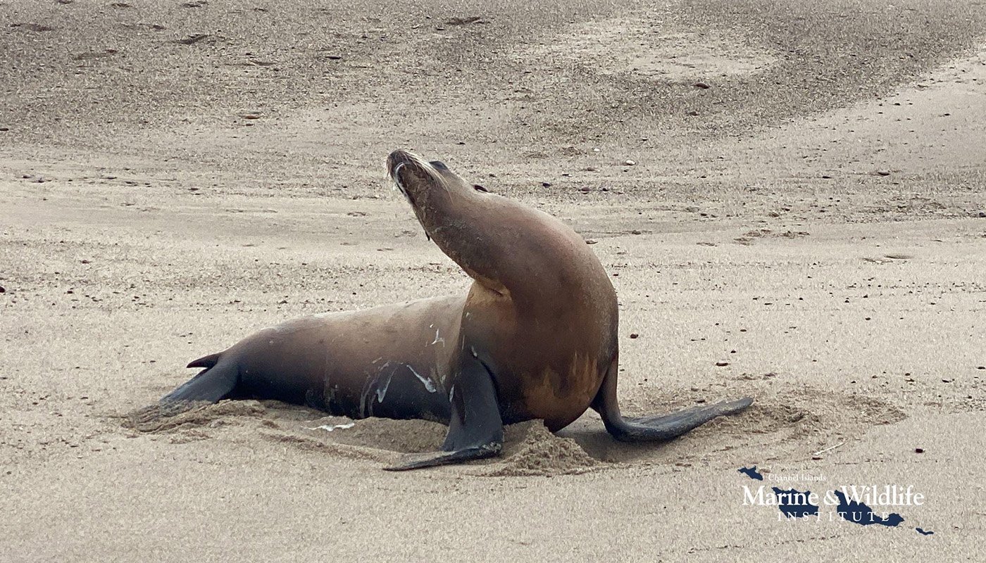
A sea lion exhibits domoic acid poisoning by stargazing and foaming at the mouth. In 2025, a domoic acid bloom has impacted many hundreds of marine mammals in California. Image credit: Channel Islands Marine & Wildlife Institute.
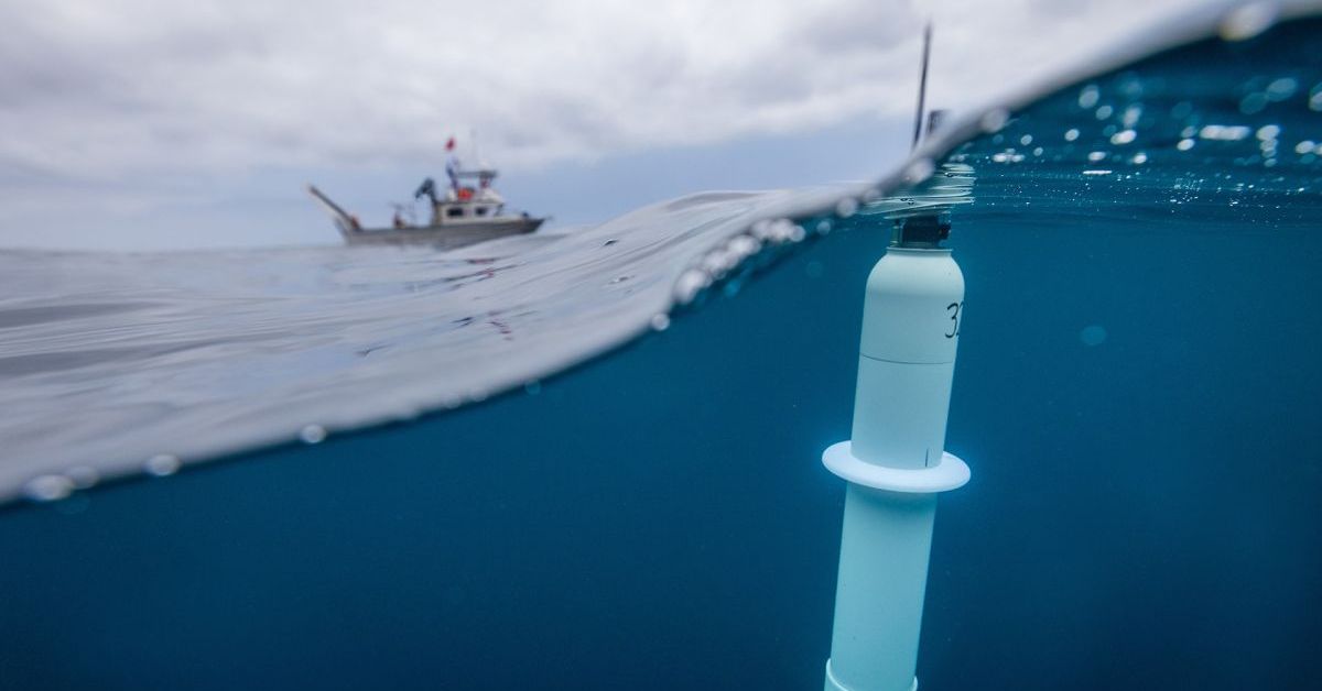
At UC San Diego’s Scripps Institution of Oceanography, this support allows scientists with the Southern California Coastal Ocean Observing System (SCCOOS) to maintain a network of underwater robots equipped with microscopes, called Imaging FlowCytobots, deployed along the coastline that take real-time images of phytoplankton to help scientists identify the microscopic culprits causing these devastating blooms. Weekly water samples are also taken at piers and coastal sites to measure plankton, toxin and nutrient concentrations, and an underwater autonomous glider network is deployed 24 hours a day to inform researchers about ocean conditions like upwelling that can drive these harmful algal blooms.
“None of the monitoring and modeling that we do to mitigate harmful algal blooms could be done without NOAA support,” said Clarissa Anderson, a biological oceanographer and director of SCCOOS, the regional observing system that collects and delivers ocean data to coastal decision makers. “Mammal rescue groups and public health managers rely on these forecast and observation products for resource management and event sampling to protect lives. If those communities are flying blind, they are unable to respond to these extreme events in real-time.”
Beyond harmful algal blooms, the NOAA-supported SCCOOS also provides ocean surface current data used for oil spill response and to improve efficiency of U.S. Coast Guard search and rescue; helps fund wave buoys that inform under-keel clearance decisions for tankers and cargo ships entering the Port of Los Angeles; and provides real-time environmental data to sustainable commercial and recreational fishing industries.
In 2025, NOAA has been targeted by the federal administration to cut at least 15% of its workforce, and could see significant cuts and restructuring in next year’s federal budget. Below, we’ve outlined how NOAA support is critical for providing environmental intelligence necessary to keep the public safe, fisheries healthy, and Americans at large better prepared for extreme weather impacts to society.
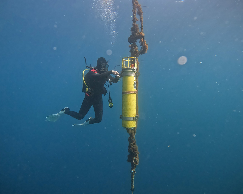
Project scientist Kasia Kenitz performs maintenance on an Imaging FlowCytobot, an instrument that takes real-time images of phytoplankton to help scientists identify the microscopic culprits causing devastating harmful algal blooms. Image credit: Rich Walsh/Scripps Institution of Oceanography at UC San Diego.
Keeping Seafood Sustainable and Safe
The fires that destroyed several Los Angeles-area neighborhoods had an unusual consequence in January. The ash from the contents of burning homes — including toxins from cleaning products to furniture materials — dropped onto the ocean surface off the coast and mixed into the seawater.
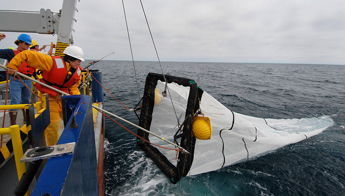
A Scripps scientist recovers a midwater trawl net used to collect juvenile fishes from surface waters on a CalCOFI expedition. These surveys provide information about the health of marine life populations vital to healthy fisheries. Credit: James Wilkinson.
By chance, one of the quarterly cruises of CalCOFI, a joint Scripps/NOAA/California Department of Fish and Wildlife (CDFW) program, was taking place at the time. CalCOFI, short for California Cooperative Oceanic Fisheries Investigations, conducts comprehensive surveys of the state’s coastal waters along a fixed grid of stations.
In this instance, that meant that the routine seawater samples collected by researchers off Santa Monica and other stations as much as 100 miles off the coast contained potentially hazardous materials in addition to the assemblages of microorganisms, fish larvae and eggs, and minerals they would expect to find.
Now an intensive analysis campaign by Scripps and NOAA seeks to understand what risks those toxins could pose to marine ecosystems and to the people who consume seafood caught in this region. The program leverages 75 years of data that scientists can use to establish comparative baseline conditions for ocean water samples, follow the progress of the development of fishes in the aftermath of the fires, and alert the public to potential threats to the health of seafood consumers.
“These long-term measurements are never more important than when catastrophe strikes — from fires to oil spills. CalCOFI's consistent data provide a critical baseline to understand how marine ecosystems respond, recover, or shift in the face of sudden environmental stress.”
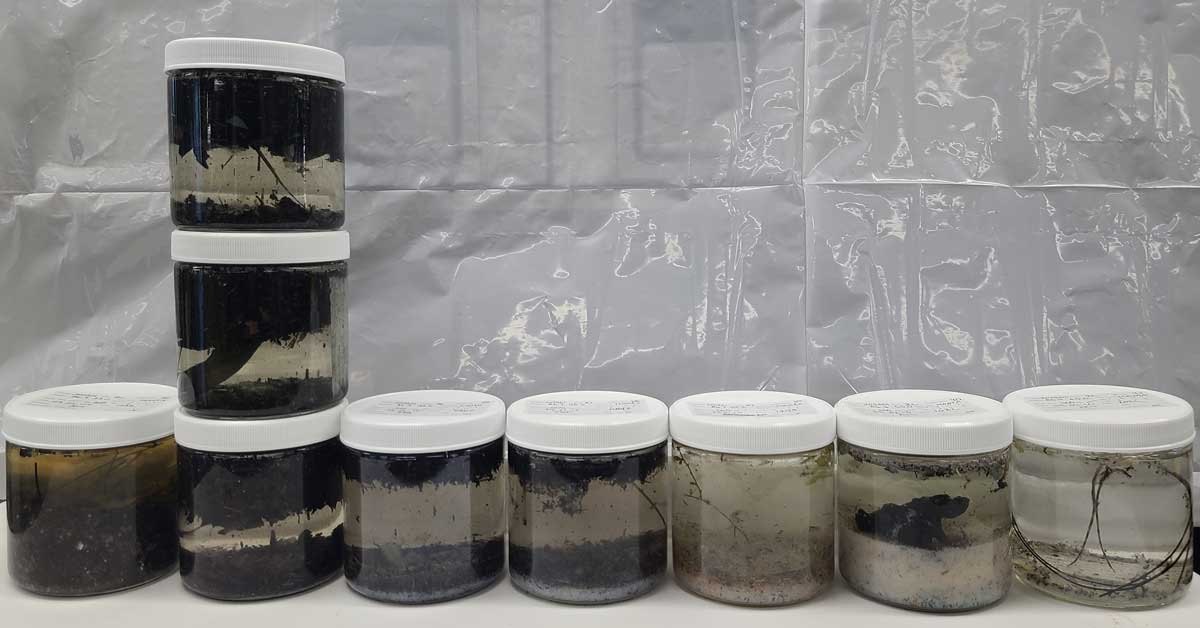
Charred debris collected in CalCOFI seawater samples from an expedition that occurred during the Los Angeles wildfires in January 2025. Photo: Rasmus Swalethorp
State leaders and members of the seafood industry credit the availability of CalCOFI data as an essential tool that protects the economy and the jobs of people who rely on that industry to thrive.
“California's ocean monitoring program, CalCOFI, has been taking the pulse of the ocean ecosystem for most of the last century,” said Brice Semmens, director of CalCOFI at Scripps Oceanography. “These long-term measurements are never more important than when catastrophe strikes — from fires to oil spills. CalCOFI's consistent data provide a critical baseline to understand how marine ecosystems respond, recover, or shift in the face of sudden environmental stress.”
Observations, Technology Development Advances Environmental Intelligence
At Scripps, one of the institution’s most important scientific contributions is the long-term observing programs it operates that give society a longer view of the state of our planet. The Keeling Curve, started in 1956 by Charles David Keeling, was fundamental to capturing the see-sawing but ultimately upward trend in atmospheric carbon dioxide (CO2) concentration.
These measurements continue under the leadership of Keeling’s son, Ralph Keeling, who with NOAA support has also been measuring a downward trend in atmospheric oxygen since 1990, which can serve as an environmental indicator helping pinpoint carbon sinks on ocean and land.
“Imagine a world without major economic indicators, such as the Dow Jones Industrial Average, NASDAQ, or unemployment rates,” said Ralph Keeling, geochemist and director of the Scripps CO2 Group. “These datasets are critical to get a large-scale view. The environmental outlook provided by these observing programs is also a critical part of the economic outlook. We can’t afford to be in the dark on environmental change, given the agricultural, economic and national security consequences.”
As technology has advanced, and Scripps scientists invented new technologies to track the global ocean, NOAA investment has provided critical support to maintain operations, technology advancement and make data broadly accessible.
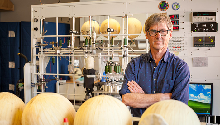
Geoscientist Ralph Keeling in his lab where he measures atmospheric carbon dioxide and oxygen concentration. Credit: Scripps Institution of Oceanography/UC San Diego.
Argo, a technology invented at Scripps in the early 1990s that is now a program supported by 30 countries, measures water properties in every ocean on the planet. Argo floats are robotic instruments that drift with the ocean currents and move up and down between the upper ocean and ocean surface, where they text data on temperature, salinity and currents to satellites in near-real time. Newer Deep Argo technology can take measurements down to 19,600 feet (6,000 meters) giving scientists insights on the state of the most unexplored area of the planet. Biogeochemical Argo floats are equipped with advanced sensors measuring oxygen, nitrate, pH, chlorophyll and more, telling scientists key information about ocean acidification and oxygen loss in the ocean.
Data collected from Argo are also key in global weather forecasting and developing seasonal scale forecasts like El Niño and La Niña, for producing drought forecasts, and for mapping marine heatwaves, which can be detrimental to the $10 billion fishing industry. Biogeochemical Argo can also be a tool to validate marine carbon dioxide removal technologies by analyzing carbon uptake in the ocean.
“The ocean makes up 70% of our planet’s surface, and what happens in the ocean has implications for everyone — even across the continental United States.”
“The ocean makes up 70% of our planet’s surface, and what happens in the ocean has implications for everyone — even across the continental United States,” said Sarah Purkey, physical oceanographer and Argo lead.
When extreme weather events like hurricanes and atmospheric rivers, which initiate from the ocean, threaten U.S. communities, another program at Scripps is providing critical, real-time information to improve forecasts essential for global weather and for generating life-saving alerts ahead of extreme weather events. The Global Drifter Program supports a network of drifting buoys which take observations at the air-sea interface of temperature, currents, waves, wind, and barometric pressure. Designed, built and operated by the Lagrangian Drifter Lab at Scripps, these buoys are deployed from ships and planes — including by U.S. Air Force Hurricane Hunters — into the path of extreme weather events headed toward U.S. coastlines.
“The data from the Scripps drifting buoys improves forecasts for the safe routing of planes and ships, and improves forecasting the precipitation and landfall location of hurricanes and atmospheric rivers,” said Luca Centurioni, physical oceanographer, scientific lead of the Global Drifter Program and director of the Lagrangian Drifter Lab at Scripps. “The program costs each taxpayer 0.1 cent a year — and two-thirds of that funding goes to small and large businesses that supply parts and services. The return on investment for the public safety impacts is huge.”
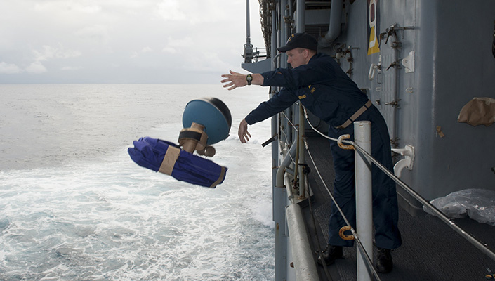
Lieutenant Jeffrey Grabon launches a global drifting buoy into the Pacific Ocean from the USS Pearl Harbor in 2013. The buoys are often deployed from ships and planes into the path of extreme weather events headed toward U.S. coastlines. Credit: U.S. Navy photo by Mass Communication Specialist 1st Class Lowell Whitman.
Weather Forecasts and Water Resiliency
NOAA is also home to the National Weather Service, which provides critical forecasts and weather alerts to the American public. The Center for Western Weather and Water Extremes (CW3E) at Scripps also partners with NOAA on its atmospheric river forecasting program.
“Through our research, we’ve developed a state-of-the-art regional weather model that’s the best in the world at predicting atmospheric rivers,” said Marty Ralph, research meteorologist and director of CW3E. “For us to do those things, we really need observations and observing platforms such as aircraft, buoys and satellites from NOAA.”
For atmospheric rivers, in addition to air-sea measurements from the drifting buoys, observations also include those captured from the NOAA Gulfstream-IV science jet. Since 2016, Scripps and the NOAA Environmental Modeling Center have co-led the now operational Atmospheric River Reconnaissance program, which deploys NOAA and Air Force Hurricane Hunters on data collecting missions to deploy dropsondes through atmospheric rivers. The program has created a 12% improvement in extreme precipitation forecasts for the U.S. West Coast, ten times what normal advances in skill would occur in a year, as well as improvements to predicting storms that impact the continental U.S.
“Through our research, we’ve developed a state-of-the-art regional weather model that’s the best in the world at predicting atmospheric rivers. For us to do those things, we really need observations and observing platforms such as aircraft, buoys and satellites from NOAA.”

In February 2025, the NOAA Hurricane Hunters flew a data-collecting mission over an atmospheric river approaching the U.S. West Coast. Credit: Erik Jepsen / UC San Diego.
And while improved forecasts are vital for hazard planning and public safety, the program is also increasing water supply. With better science-informed forecasts, water managers have more tools to make decisions about retaining water if no storms are coming, or releasing water to prevent hazardous flooding. This program, known as Forecast-Informed Reservoir Operations (FIRO), is increasing water availability at reservoirs in Sonoma County, Southern California, and in the Yuba-Feather Rivers watershed.
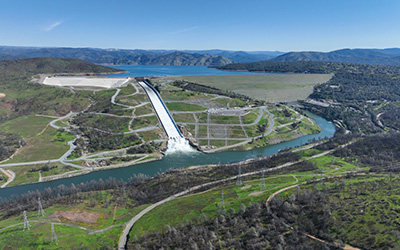
Oroville Dam in Butte County, California. A program known as Forecast-Informed Reservoir Operations is helping to increasing water availability and flood protection at reservoirs including Sonoma County, Southern California and in the Yuba-Feather Rivers watershed. Photo credit: Sara Nevis/California Department of Water Resources.
“Atmospheric rivers are critical to California’s water supply but have also caused Yuba County’s most devastating floods, including in 1986 and 1997,” said John James, director of resource planning for Yuba Water Agency. “With adaptive tools like FIRO and our planned Atmospheric River Control Spillway at New Bullards Bar Dam, we’re essentially gaining the amount of flood storage that would historically only be created through building additional infrastructure. In this case, we’re enhancing our existing infrastructure and using the latest in science and technology to modernize flood operations and improve public safety.”
According to Ralph, this innovation and partnership with water managers is essential.
“With longer droughts, deeper droughts and bigger storms in between them, we have to use every drop of water that much more effectively," says Ralph. "In the reality of California’s volatility between drought and floods, FIRO is helping us improve flood protection and manage precious water resources. NOAA is a critical part of keeping that going.”
To learn more about how to support federal research, visit UC San Diego’s Behind Every Breakthrough site.
Share This:
You May Also Like


Stay in the Know
Keep up with all the latest from UC San Diego. Subscribe to the newsletter today.