ALERTCalifornia Launches to Provide Essential Tools to Understand and Adapt to Natural Disasters
UC San Diego’s ALERTCalifornia public safety program leverages novel technology and cutting-edge research to understand the causes, behavior and aftereffects of wildfires and other natural disasters in the Golden State
Story by:
Published Date
Story by:
Topics covered:
Share This:
Article Content
The University of California San Diego recently launched ALERTCalifornia, a collaborative public safety program providing the tools to prepare for, respond to and recover from wildfires and other natural hazards. Formerly part of the ALERTWildfire camera network, the newly expanded state-focused program manages more than 1,000 pan-tilt-zoom wildfire monitoring cameras and sensor arrays in California, and collects data that provides actionable, real-time information to inform public safety for natural disasters.
With this launch, ALERTCalifornia is debuting an updated third-generation wireless camera network, and will prioritize cutting-edge research in response to increasingly frequent and severe climate-driven disasters such as fires, floods, atmospheric rivers and landslides. Scientists are undertaking advanced data collection and processing to gain a better understanding of natural disasters’ long-term impacts on air quality, water quality, soil quality and human health in California. This two-pronged camera and data-driven approach will aid in the development of effective and time-critical plans for natural disaster prevention, response and mitigation.
“The program will spawn invaluable research and mitigation plans that will increase the state’s resiliency towards the new extreme fire risk,” said Neal Driscoll, director of ALERTCalifornia and geoscientist at UC San Diego’s Scripps Institution of Oceanography. “Data acquired in the highest fire-threat regions will significantly empower firefighters, first responders, legislators, city planners and scientists for years to come.”
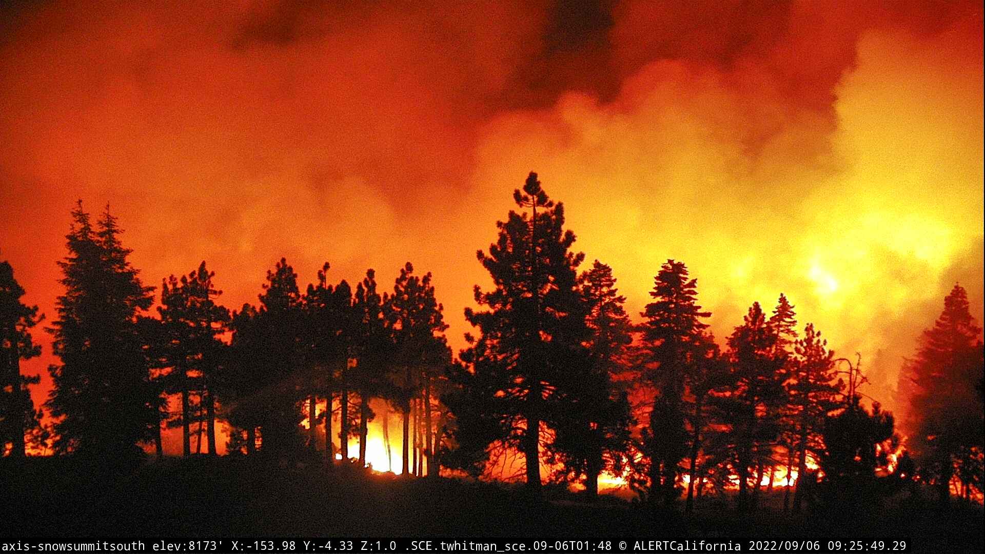
The Radford Fire viewed from an ALERTCalifornia camera. The camera network helped firefighters battle the September, 2022 wildfire in San Bernardino National Forest, which burned more than 1000 acres near the resort community of Big Bear, CA.
Camera Interface Improvements
The launch of ALERTCalifornia includes major camera network interface improvements to enhance safety and efficiency based on feedback from partners and collaborators such as the California Department of Forestry and Fire Protection (CAL FIRE). Fire and emergency management personnel input was essential to create the new, mobile friendly, public website interface, which now features a camera view “quilt” or collection of camera views targeting a specific area of interest as well as panoramas that show a high-resolution stitched-together 360-degree view for each camera. In addition to the publicly available camera website, ALERTCalifornia created customized state-of-the-art camera command and control centers and trained first responders at the local, regional, state and federal government levels to quickly and efficiently use the cameras.
“The benefits of UC San Diego’s ALERTCalifornia program are many,” said CAL FIRE San Diego County Unit Chief Tony Mecham. “They fit well in the National Cohesive Wildland Fire Strategy by enhancing community wildfire resiliency, forest health monitoring, public outreach, as well as providing crucial early situational awareness for aggressive fire response.”
The camera network’s usefulness expands beyond wildfires. Recently the live feeds were used to monitor the record-breaking Sierra Nevada snowpack, statewide flooding, landslide hazards and road conditions associated with the atmospheric rivers that hammered the state starting in December 2022.
“This program was originally funded as a basic research project by the National Science Foundation and has significantly helped wildfire and hazard response in our state” said California State Senate President pro Tempore Toni G. Atkins (D-39). “I’m looking forward to seeing how this effort will continue to make California more resilient to the impacts of climate change.”
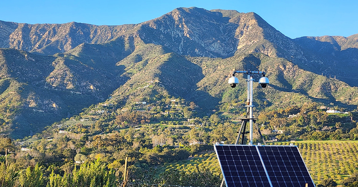
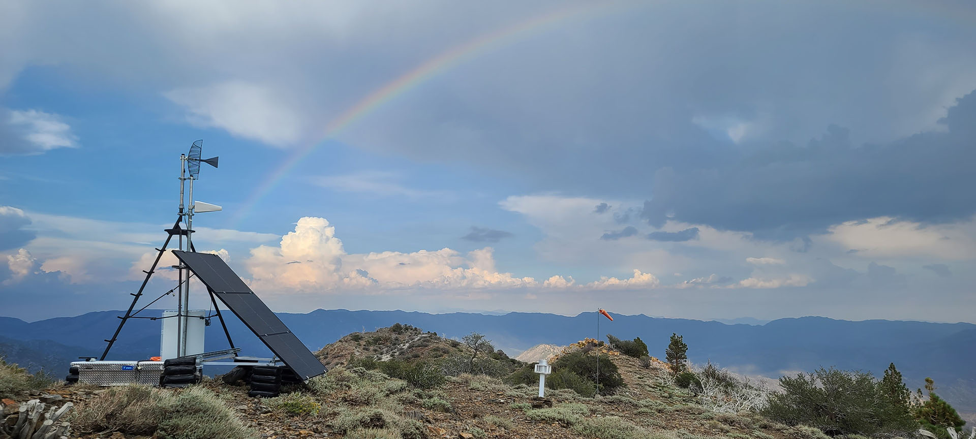
ALERTCalifornia’s field teams continue to erect new cameras to enhance coverage across the state as California endures more frequent natural disasters. New cameras were installed in Los Angeles, Santa Barbara and Madera counties since the start of the new year. The high-definition cameras are able to pan, tilt, zoom and perform 360-degree sweeps and provide 24-hour monitoring with near-infrared night vision capabilities. Each camera can view as far as 60 miles on a clear day and 120 miles on a clear night. Using the cameras and associated tools, firefighters and emergency managers can rapidly confirm fire ignition, quickly scale fire resources, monitor fire behavior, support evacuations through enhanced situational awareness and monitor fires through containment.
“Over the past two years, the ALERTCalifornia cameras in our unit have significantly improved the situational awareness of our response personnel on wildland fire calls throughout the unit,” said CAL FIRE San Mateo-Santa Cruz County Division Chief, Richard Sampson.
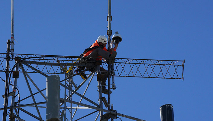
An ALERTCalifornia technician adds a new camera sensor to the network.
Beyond imagery, select new cameras have additional sensor arrays that incorporate the latest infrared technology. These sensor arrays allow emergency managers to identify hotspots and flare-ups through smoke cover, and provide real-time situational awareness that enhances the efficacy of firefighting efforts and safety. The ALERTCalifornia team also made advancements in mobile field camera and sensor technology by creating small temporary platforms that are easily assembled and removed seasonally. These platforms fill the need for monitoring in high-risk areas with little to no impact to sensitive habitats and sacred tribal lands.
Located deep in in Sequoia National Forest, the Bald Mountain Sequoia camera is one of the most remote in ALERTCalifornia network.
Data Management and Research Advancements
Driscoll and co-lead Falko Kuester, structural engineering professor at UC San Diego’s Jacobs School of Engineering and a researcher at UC San Diego's Qualcomm Institute, are working collaboratively across disciplines to enhance management and analysis of the network's massive amounts of incoming data. Currently, the system acquires one gigapixel's worth of image data from the camera network, which translates to one billion data points per second. ALERTCalifornia's archive of recorded and processed raw data is growing as its camera network expands and new types of data are gathered.
“ALERTCalifornia advances novel remote sensing, data synthesis and processing as well as modeling and simulation techniques, creating a proverbial big-data firestorm,” said Kuester. “We are taking on this challenge through fundamental and applied research, and development of the next generation of cyberinfrastructure and visual analytics techniques for extreme events data. Our work informs the creation and use of a large-scale digital-twin of California that aggregates the different sensor streams and provides a means to study them, turning data into insights, knowledge and action.”
In addition to the data recorded passively through the camera network, ALERTCalifornia’s field teams are actively working with partners to manually collect data using the latest tools and technology. Drones and aircraft are fitted with equipment that uses light detection and ranging (LiDAR) and hyperspectral imaging—the capturing and processing of an image at a very large number of wavelengths—to characterize the health of forests.
Accurately characterizing fire-prone areas, enabling analytics, researching forest health and mapping wildfire fuels are just some ways that ALERTCalifornia’s data contributes to external research. Groups like CAL FIRE are using these open-source data to create models of wildfire behaviors. New algorithms are being developed so that researchers can test fire detection computer models and machine learning against real-world wildfire examples recorded by ALERTCalifornia’s camera network.
“The collection of new high-density LiDAR and multispectral data will add to the program’s effectiveness and improve fire resiliency in California by accurately characterizing biomass, and as such, possible bio-fuels and moisture content, enabling analytics and extensive research on fuels and forest health, and mapping wildfire fuels to accurately model wildfire behavior,” said Driscoll.
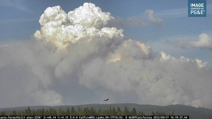
An ALERTCalifornia camera captures a vulture silhouetted against 2022’s Mosquito Fire, which burned nearly 78,000 acres in Placer and El Dorado counties.
To date, ALERTCalifornia’s drone and aircraft teams have collected 30,000 square miles of high-density LiDAR and multispectral data of all of California’s Tier 2 (Elevated Risk) and Tier 3 (Extreme Risk) fire threat regions as defined by the California Public Utilities Commission in the Sierra Nevada mountains. In 2023 and 2024, ALERTCalifornia plans to acquire over 70,000 additional square miles of LiDAR and multispectral data. These huge datasets will allow ALERTCalifornia’s research team and partners to gain a better understanding of California’s ever-changing wildfire fuels and create a baseline to understand the impacts of future natural disasters.
These massive datasets provide researchers and emergency personnel an unprecedented understanding of fire causes and behavior, and now they will also be used as a baseline to study post-fire ecosystem impacts and recovery. The high-quality data is open access and is available to all government agencies, researchers, utilities and the general public in order to further democratize the access to remote sensing data, creating an ecosystem that promotes innovation and engagement.
In addition to the immediate public safety challenges of understanding explosive wildfires, the research team is studying the long-term effects that impact Californians. Communities often experience secondary impacts of cascading hazards such as post-fire debris flows, floods and erosion near burned areas. These impacts can occur weeks, months or years after wildfires. Additionally, long-term post-fire impacts to air quality, water quality, soil quality and human health are ongoing active research areas. ALERTCalifornia will provide the open-source data and work with collaborators including California government agencies at all levels to tackle these challenges head-on.
The ALERTCalifornia cameras can be viewed by the public 24 hours a day at ALERTCalifornia.org
Learn more about research and education at UC San Diego in: Climate Change
You May Also Like


Stay in the Know
Keep up with all the latest from UC San Diego. Subscribe to the newsletter today.